Publications & Maps

Mail Steamship Routes
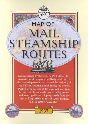
Mail Steamship Routes Cover
Map of Mail Steamship Routes
Price: £9.99
Overview
Commissioned by the General Post Office in 1937, by the time MacDonald Gill completed ‘Mail Steamship Routes’ he was already a renowned designer and illustrator.
This bright and lively world map depicts the Royal Mail steamship routes that carried the majority of the UK’s international mail during the 1930s, framed by some delightful illustrations of the transport links through which the post would pass. A series of eleven images tracing the development of sailing vessels from the time of King Alfred to the RMS Queen Mary is bound to appeal to enthusiasts of postal and maritime history.
The sheet map (approx. 62cm x 76cm) is folded in a wallet and comes with an introduction by BPMA Curator Julian Stray. He highlights Gill's achievements for the 1930s GPO poster campaign after creating the new GPO logo in 1934 and describes the development of the mail steamship routes as depicted on this colourful map.


